The Weirdest Clouds: Mammatus Clouds (Tons of Photos)

Weirdest Clouds: Mammatus
What is it?
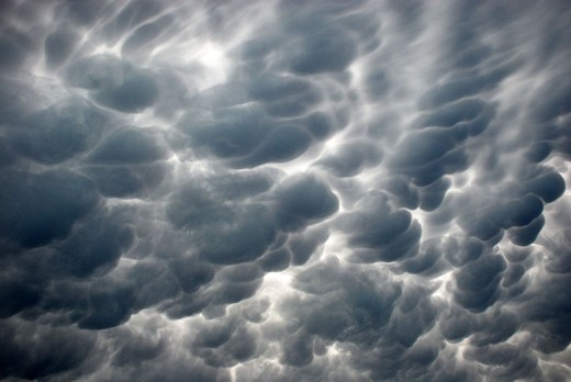
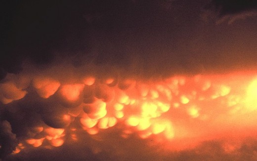
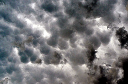
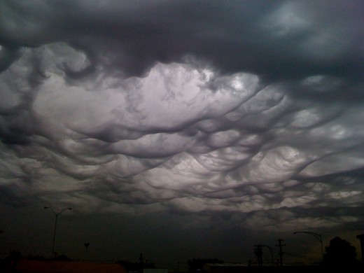
Mammatus clouds (also known as mammatocumulus or breast clouds) are a uniquely-shaped type of cloud formation often associated with strong storms and tornadoes. Although mammatus themselves do not produce severe weather, the clouds are usually dark and semi-transparent, creating an ominous atmosphere. In fact, this type of cloud formation signifies a weakening storm.
Individual mammatocumulus can be 1 - 3 km in diameter and together often can cover over hundreds of kilometers of sky. The lumps themselves can either be ragged or smooth and usually do not cause precipitation but rather evaporate and eventually disappear.


How do mammatus clouds form?
Often times mammatus clouds form during a thunderstorm. During a thunderstorm there is a strong updraft which draws water molecules up from below. Up in the sky, the water condenses, becoming part of the thunderstorm cloud (anvil cloud). Because of the updraft, the water still rises and rises until it gets to the altitude of 57,000 feet. At this altitude, the water freezes into ice crystals and spreads out side to side. The ice crystals, grouped together, begin to sink because they have a higher density than the air. When the sinking ice crystals reach the bottom of the thunderstorm cloud, they sink a little bit more because of the large clusters of ice, and then stop creating the breast-like pouch clouds: mammatus.
To sum that up into one sentence: mammatus clouds form from cold icy air sinking from the top to the bottom of a thunderstorm cloud.

How rare are they?
Mammatus clouds are far from the rarest type of cloud, but they are uncommon. The clouds are known to form in most places around the world, but only under certain circumstances (described above).
Mammatus facts
Common myth: mammatus clouds do not continue to sink, becoming tornadoes.
They also do not guarantee a future tornado will form.

Mammatus clouds together with cumulonimbus can be very dangerous to fly aircraft through.

On average, individual mammatus pockets last for about 10 minutes.

A whole cluster can last from 15 minutes to a couple hours.

Usually composed of ice, some mammatus pouches can contain nearly 100% water.

In certain circumstances -- if the lumps contain enough ice crystals -- mammatus clouds may cause hailstorms.


If you are still interested in more mammatus
In my opinion, the best pictures of mammatus clouds are found here: http://www.myinterestingfiles.com/2007/12/mammatus-clouds-rare-beautiful.html
Upload your own pictures and earn money
If you are interested in uploading your own pictures and making money from them, consider signing up for Fotolia. Fotolia is a stock photo website where people are willing to pay to be able to use good photos and there is good potential to earn from your photos. The more you upload, the more you will earn.
More Rare and Amazing Clouds
- 20 Nacreous Clouds & Fire Rainbow Pictures - Natural...
20 amazing Nacreous Clouds and Fire Rainbow pictures. Also known as polar stratospheric clouds and circumhorizontal arcs. - The Weirdest Clouds: Arcus Clouds (Roll Clouds and S...
Have a look at some weird clouds. Arcus clouds (roll clouds & shelf clouds) pictures and info. - Bermuda Triangle Theories
Bermuda Triangle Theories: over 100 missing ships and airplanes, over 1000 people dead. Have a look at the strongest theories of the Bermuda Triangle and the weirdest experiences as to the disappearances in the Bermuda Triangle with some great videos


